
Everest Base Camp by Road: Permits, Costs and Altitude in 2026
From Lhasa to the 5,200 m viewpoint: permits, shuttle fees, staged acclimatisation and the real cost of an Everest trip.
From Lhasa to the 5,200 m viewpoint: permits, shuttle fees, staged acclimatisation and the real cost of an Everest trip.
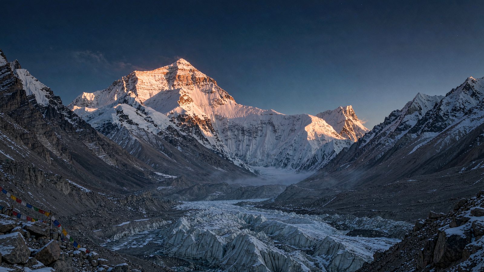
Most travellers who say they are "going to Everest" will never set foot on the summit. What they actually reach is the Everest Base Camp viewing area at roughly 5,200 metres on the Tibetan side, where the north face of the 8,848.86-metre peak rises above the moraine of the Rongbuk Glacier. The real barriers are not fitness. They are three documents, two speed-controlled mountain roads, and an altitude that does not negotiate. This guide sets out the whole route from Lhasa to that first clear view, using the rules in force in 2026.
Three things to settle before anything else
Everest has two approaches. The south side is in Nepal, reached by flying to Lukla and trekking for well over a week. The north side is in Tibet, China, and can be done entirely by vehicle from Lhasa via Shigatse and Tingri. The Chinese-side endpoint for ordinary visitors is the tourist base camp at about 5,200 metres. No climbing skill and no training are required. If you have no severe heart or lung condition and can acclimatise, you can stand there.
Reaching the viewing area is not the same as climbing the mountain. Summit expeditions begin above base camp and require a climbing permit, certified guides, medical clearance and a substantial budget. Some packages marketed as "Everest climbing" are in fact vehicle trips to the viewing area. Always ask what the final altitude of the itinerary is.
One rule is absolute: foreign visitors cannot travel in Tibet independently. You must be organised by a licensed agency, accompanied throughout by a guide and driver, with accommodation and route filed in advance. This is a condition of approval, not a recommendation.
The three documents foreign visitors need
- Chinese visa or visa-free entry: you need valid entry status before a Tibet permit can be issued. Visas are decided by consulates; no agency can guarantee an outcome, and we only help check the document list.
- Tibet Travel Permit: issued by the regional tourism authority and obtainable only through a licensed agency. Apply 15 to 20 working days ahead with a passport bio page, visa page, occupation details and itinerary. The permit is a paper document and is checked when you fly or take the train into Tibet.
- Border-area permit: mandatory for Everest, with the destination written as Tingri County, Shigatse. Since 15 April 2026 the permit is fully electronic: apply in the National Immigration Administration mini-programme with a face scan, state your destination and purpose, and it is usually issued within minutes. It is free and valid for three months, and the old trip to a police station for a paper certificate is no longer needed.
The order matters: entry status first, then the Tibet permit, then the border permit. Everest also lies in a restricted area, so the route must appear on the permit itinerary. Changing plans mid-trip can get you stopped at a checkpoint.
Getting there: three legs from Lhasa
The drive is about 700 kilometres. The road is good but speed limits are enforced strictly, so split it over two days.
- Lhasa to Shigatse: about 250 to 270 kilometres on National Highway 318, four to five hours by road. The Fuxing high-speed train takes about 2.5 hours for a 64 yuan second-class seat and is the most comfortable option. Shigatse sits at 3,800 metres and is the main supply base, with fuel, hospitals and proper hotels.
- Shigatse to Tingri: about 240 kilometres, four to five hours. The road crosses the Gyatso La pass at 5,248 metres, the highest point of Highway 318, before descending into Tingri County. Tingri town has fuel, food and oxygen supplies.
- Tingri to the gate, then the transfer hub: about 40 kilometres to the reserve gate and another 110 kilometres of switchbacks to the visitor transfer centre, roughly two hours. The road passes the Gawu La pass at about 5,210 metres, one of very few places on earth where five 8,000-metre peaks can be seen at once: Makalu, Lhotse, Everest, Cho Oyu and Shishapangma. This is the stop worth taking slowly.
Tickets, shuttle buses and vehicle fees in 2026
The reserve uses seasonal pricing, and no private vehicle may enter the core zone. Everyone transfers to an electric shuttle at the hub. The eighth winter tourism promotion ended on 15 March 2026, and normal charging resumed at midnight on 16 March 2026.
| Item | Reference price (CNY) | Notes |
|---|---|---|
| Reserve entrance, high season May to October | about 160 to 180 per person | About 90 in low season; confirm at the ticket hall |
| Shuttle bus, return | about 120 per person | Hub to Rongbuk viewing area; compulsory |
| Vehicle environmental fee | about 320 to 400 per car | Small passenger car, charged per vehicle |
| Border permit | free | Electronic since 15 April 2026 |
Prices are approved by the regional and municipal development and reform commissions and posted at the ticket hall; the Tingri culture and tourism bureau issued a formal notice on 1 May 2026. Rates can be adjusted, so check the posted price on the day rather than budgeting from an old blog post. Sharing a vehicle spreads only the vehicle fee; entrance and shuttle are charged per person.
What you actually see, and where to sleep
The viewing area sits around Rongbuk Monastery at roughly 4,980 to 5,200 metres, facing the north wall directly. On clear mornings and evenings the summit catches the sun first, turning orange-red before fading to white. There are no hotels, only tent camps with shared dormitory beds and a few basic guesthouses. Nights hover near freezing.
- Tent camp: dormitory beds, a few dozen yuan each, thick quilts and a dung stove for warmth, very limited washing. Not advisable if you already feel the altitude.
- Rongbuk Monastery guesthouse: slightly lower, sturdier rooms, very few of them, book ahead in season.
- Everest town near Tashi Dzom: about 50 kilometres away and much lower. New oxygen-supplied hotels opened from May 2026 with room-wide oxygen enrichment, a better choice if you sleep badly or your blood oxygen drops. The trade-off is a one-hour drive back in for sunrise.
- Tingri town: the safest option at around 4,300 metres with plenty of hotels, but about three hours each way, so sunrise means a very early start.
Our standard pattern is to spend the first night in Shigatse acclimatising, the second in Tingri or Everest town, and drive in on the third morning for sunrise before returning the same way. That keeps the 5,200-metre exposure to daylight hours and returns you to lower ground to sleep, which sharply reduces altitude risk.
Altitude is the one thing you cannot negotiate
Going from 3,650 metres in Lhasa to 5,200 metres at the camp is a fast ascent. Oxygen availability is roughly half that at sea level, and being generally fit grants no exemption.
- Staged acclimatisation: spend at least two nights in Lhasa before heading west, and do not go above 4,000 metres on day one.
- Red lines: persistent headache that painkillers do not touch, breathlessness at rest, breathlessness on flat ground, blue lips, confusion, or pink frothy sputum. Any one of these means descend immediately and seek medical help; do not wait for morning.
- Avoid: hot showers on arrival, alcohol, strenuous exercise and late nights; and never ascend with an unresolved cold, which can turn into pulmonary oedema.
- Carry: portable oxygen (sold in Tingri and Shigatse), glucose, ibuprofen, cold medicine. Herbal preventives have weak evidence, so do not treat them as insurance.
- Who should not go: pregnancy, severe hypertension, coronary disease, chronic obstructive pulmonary disease, recent surgery. Above 65, get an ECG and blood-oxygen assessment first.
When to go for the best chance of a clear summit
- April to May: the best window. Pre-monsoon air is clear, cloud cover is low, and the odds of a full summit at dawn are highest. This is also when climbing teams assemble, so base camp is at its liveliest.
- Late September to October: second best. The monsoon has cleared, skies reopen, temperatures are slightly lower and crowds thinner.
- June to August: monsoon. Warm moist air from the Indian Ocean wraps the massif in cloud for days; whether you see anything is luck, and landslides are more likely.
- November to March: visibility is often good but temperatures can fall to minus 20 Celsius, some sections ice over and close, and the wind at the viewing area is brutal.
Even in the best season, plan two mornings at the camp. The cloud often breaks just when you have given up, and one extra day changes your hit rate completely.
Packing: dress for minus five
- Warm layers: fleece plus down jacket, thermal base layer, thick socks, gloves, wool hat. Wind at the viewing area makes it feel five to eight degrees colder.
- Sun protection: UV at this altitude is extreme. SPF50 sunscreen, UV-rated sunglasses (snow blindness is genuinely painful), wide-brim hat, lip balm.
- Medicine: glucose, ibuprofen, cold and stomach medicine, personal prescriptions, plus portable oxygen.
- Documents: passport, printed Tibet permit, offline screenshot of the electronic border permit (mountain signal is unreliable), itinerary copy.
- Other: power bank (cold drains batteries fast), vacuum flask, wet wipes, small cash notes, since tent camps may not accept mobile payment.
Five common misconceptions
- "We can go straight from Lhasa to Everest." No. Permit, border permit and filed itinerary are all required; improvising usually ends at a checkpoint.
- "Renting a car gives more freedom." Foreign visitors cannot self-drive in Tibet, and private cars are barred from the core zone in any case.
- "Sleeping at base camp for the stars is easy." It is allowed, but 5,200 metres overnight is a heavy load for most people; the star photograph is often paid for with a night of vomiting.
- "The ticket is expensive, so a guide is optional." A guide is a condition of the permit, not an add-on. Without accompanying staff the trip is not authorised.
- "Summer is best because it is warm." Summer is the monsoon, and statistically the worst season for seeing the summit.
Let people who know the rules handle the paperwork
The hard part of an Everest trip is never the scenery. It is getting documents, speed limits, altitude and weather to line up at once. Jadetour works the Tibet section backwards from your arrival date: permit application timing first, then a staged route of Lhasa acclimatisation, a Shigatse rest day and the Tingri approach, and finally a seasonal recommendation on whether to sleep at the camp or in Everest town. We do not promise visa or permit approvals, but we will give you the document list, the deadlines and a fallback plan in one go. If you are planning a trip to 5,200 metres, send us your dates and group size and we will start with a feasibility check.
Need help planning this trip?
Tell us your travel dates and group size — we reply within 24 hours.
WhatsApp +86 183 1705 8017 · WeChat 18317058017
Destinations in this guide
Related Tours
More Guides
Flying with a Pet to and from China: Cabin, Hold and Quarantine in 2026
Cabin, live-animal hold or cargo, plus quarantine certificates, the 21-day rabies rule and China entry requirements.
10/17/2026
Solo Female Travel in China: Safety, Night Transport and a 2026 Checklist
Registration, late-night rides, payments and emergency numbers: a practical 2026 checklist for women travelling alone in China.
10/17/2026
Student Travel in China: 2026 Rail Fare Rules and the Best Hands-On Activities by City
A practical guide to study tours in China: 2026 rail student fare scope, visa-free basis for camps, hands-on activities by city, and group safety standards.
10/16/2026